
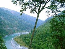
West Bengal is on the eastern bottleneck of India, stretching from the Himalayas in the north to the Bay of Bengal in the south. The state has a total area of 88,752 square kilometres (34,267 sq mi). The Darjeeling Himalayan hill region in the northern extreme of the state belongs to the eastern Himalaya. This region contains Sandakfu (3,636 metres / 11,929 feet)—the highest peak of the state. The narrow Terai region separates this region from the plains, which in turn transitions into the Ganges delta towards the south. The Rarh region intervenes between the Ganges delta in the east and the western plateau and high lands. The Chola range is situated on the Sikkim and Bhutan border. The highest peak is Rishila. The town of Kalimpong is situated in this region. Neora Valley National Park is located here. The relatively low-height Buxa-Jayanti range, a part of the Sivalik, is also located here. Among the Himalayan ranges of this region, Singalila range hosts Sandakfu which at 3,636 metres (11,929 ft) is the highest point of West Bengal. Two high peaks, Tiger Hill and Ghoom are seen near the town of Darjeeling. Many ranges branch off in different directions from Tiger Hill. Durpindara is an important mountain in the eastern part of the mountainous region. A few hills also occur in the Terai or Dooars region at the foot of the Himalayas. Some remnants of the Siwaliks can be seen in the Jalpaiguri district, where they are known as the Buxa-Jayanti Hills. A small coastal region is on the extreme south, while the Sundarbans mangrove forests form a remarkable geographical landmark at the Ganges delta.
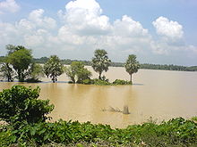
The Ganges is the main river, which divides in West Bengal. One branch enters Bangladesh as the Padma or Pôdda, while the other flows through West Bengal as the Bhagirathi River and Hooghly River. The Teesta, Torsa, Jaldhaka and Mahananda rivers are in the northern hilly region. The western plateau region has rivers such as the Damodar, Ajay and Kangsabati. The Ganges delta and the Sundarbans area have numerous rivers and creeks. Pollution of the Ganges from indiscriminate waste dumped into the river is a major problem. There are several dams on the Ganges in West Bengal used for hydroelectricity. One at Farakka, close to the point where the main flow of the river enters Bangladesh, and the tributary Hooghly (also known as Bhagirathi) continues in West Bengal past the capital. This barrage, which feeds the Hooghly branch of the river by a long feeder canal, and its water flow management has been a long-lingering source of dispute with Bangladesh. Damodar, another important tributary of the Ganges, meets the river near Bagnan, Howrah. Popularly known as "Sorrow of Bengal" due to its frequent floods, is having the large hydroelectric dam called Damodar Valley Project, built on the lines of the Tennessee Valley Authority. There is also a controversial dam at Tehri, on the Bhagirathi, one of the main source rivers of the Ganges. At least nine districts in the state suffer from arsenic contamination of groundwater, and an estimated 8.7 million people drink water containing arsenic above the World Health Organisation recommended limit of 10 µg/L. West Bengal's climate varies from tropical savannah in the southern portions to humid subtropical in the north. The main seasons are summer, rainy season, a short autumn, and winter. While the summer in the delta region is noted for excessive humidity, the western highlands experience a dry summer like northern India, with the highest day temperature ranging from 38 °C (100 °F) to 45 °C (113 °F). At nights, a cool southerly breeze carries moisture from the Bay of Bengal. In early summer brief squalls and thunderstorms known as Kalbaisakhi, or Nor'westers, often occur. Troughs of low pressure are often developed near the Bay of Bengal, resulting cyclonic storms. These are known as Ashwiner Jhar and often cause huge destruction. This season is a festive season in West Bengal due to celebration of Durga puja, Lakshmi puja and Diwali. Monsoons bring rain to the whole state from June to September. Heavy rainfall of above 250 cm is observed in the Darjeeling, Jalpaiguri and Cooch Behar district. Later, blowing westwards, the winds cause average rainfall of 125 cm in the northern plains and western plateau region. During the arrival of the monsoons, low pressure in the Bay of Bengal region often leads to the occurrence of storms in the coastal areas. West Bengal receives the Bay of Bengal branch of the Indian ocean monsoon that moves in a northwest direction. Winter (December–January) is mild over the plains with average minimum temperatures of 15 °C (59 °F). A cold and dry northern wind blows in the winter, substantially lowering the humidity level. However, the Darjeeling Himalayan Hill region experiences a harsh winter, with occasional snowfall at places.
No comments:
Post a Comment